How Hyperconnected Cities Are Taking Over the World
CityLab |
By Tanvi Misra
In the medieval period, empires battled and colluded with each other in the quest for land. The resulting system, in which nations became the main actors on the global stage, is perhaps the one most of us know best. But it’s changing.
We’re now moving toward a new era where insular, political boundaries are no longer as relevant. More and more people are identifying as “global citizens,” and that’s because we’re all more connected than we’ve ever been before. As a result, a “systems change” is taking place in the world today in which cities—not nations—are the key global players, argues Parag Khanna in his new book, Connectography: Mapping the Future of the Global Civilization. In it, Khanna, who is a global strategist and world traveler, writes:
“Geography is destiny,” one of the famous adages about the world, is becoming obsolete. Centuries-old arguments about how climate and culture condemn some societies to fail, or how small countries are forever trapped and subject to the whims of larger ones, are being overturned. Thanks to global transportation, communications, and energy infrastructure—highways, railways, airports, pipelines, electricity grids, Internet cables, and more—the future has a new maxim: “Connectivity is destiny.”
Khanna spoke with CityLab at the The Atlantic‘s 5th annual Summit on the Economy this week, where he was one of the featured speakers.
Could you explain why cities are at the heart of this global shift in power?
Cities are a key element to that evolution for many reasons. First of all, the world has become urban. If you want to understand where people are, people are in cities. Second: economics. Most of the world’s economic power is concentrated in cities, and therefore they become the pivotal entities you need to analyze to understand the world economy. Thirdly, cities are increasingly connecting to each other. They’re forging their own diplomatic networks, [which] I call “diplomacity.”
Diplomacy among cities is the return of an ancient pattern. But it also dis-intermediates state structures. Cities building physical and institutional connectivity among each other, as well as growing demographic and economic power, is how they become the drivers of this new system.
So when I say, “geography is not destiny,” I mean it in two ways. First, in the sense that connectivity as a whole liberates people from their geography. And secondly, I mean that political geography is not determinant anymore, because cities are more important.
In your book, you delve deep into the examples of well-connected cities, like Dubai, or emerging networks of connected megacities, like in the Pearl River Delta in China. Could you talk a little about these examples?
Each city that … [has] gotten itself on the map by way of elevating itself in the supply chain or by having Special Economic Zones—like Shenzhen or Dubai—is instructive to everyone around them. The key is not that we view these cities as zero-sum, because one of my main arguments is that inter-city [networking]is a positive-sum game—It’s like formula one. It’s not a zero-sum game like risk.
Cities look up to other cities in their region. The fact that Dubai is the first Middle Eastern city to be considered to be a “global city” is very inspiring to the people of Cairo, the people of Riyadh, the people of Beirut, and the people of even Addis Ababa. It’s very important that we have—in every region of the world—at least one global city with high-quality of life, high degree of connectivity.
So where do the cities that aren’t the superstars of their region fit in?
My argument is that second-tier cities shouldn’t get hollowed out and neglected. They should get more connected to the big cities. They become back offices, back-end, supply-chain providers, lower-cost manufacturing centers—they become part of that urban area.
It’s such a shame that cities [that] are actually relatively close to Chicago are so impoverished; or the state of Connecticut has some of the richest towns in America, but also some of the poorest towns, even though they’re so close.
The difference is the degree of connectivity of those cities. How easily can their residents telecommute digitally or physically commute to jobs on high-speed rail? That is the difference. More connectivity leads to more distribution of wealth, that we know for sure. We need to see this not as an opposition—“Here’s our champion city, and here’s everyone else.” Everyone needs to be a team.
You’ve emphasized the benefits of connectivity, but also mentioned some of its drawbacks. How do cities maximize the positive and minimize the negative?
Cities, just [like] countries, have to think about balancing flow and friction. So cities want to have talent come in, but not terrorists. They want to have capital come in, but not “hot money” that destabilizes their financial system, or illicit funds. They want to have diverse food and fuel imports, but they don’t want to have pathogens and diseases. That is the daily challenge.
That comes down to technologies, institutions, agencies that help … government and cities manage those things. There’s no right answer; you see many places do it in different ways. The book is basically running you through examples that are good and bad.
You also mention that cities—even connected ones—have problems with inequality and environmental sustainability. How can they solve these issues?
I think the spread of technologies across leading cities, things like the C40 does, are very very important. [C40 is a network of cities around the world working to tackle climate change.] I think it’s literally, empirically more important than our climate-treaty negotiations, because those are not binding. Meanwhile, what the C40 does … is lower the cost of technology. You don’t get China to implement CO2 scrubbers just by telling it to do so. You have to devise and deploy the technologies to make it cheap, and to make the factory owners say, “This will not harm my output.”
Investing in connectivity within megacities is how you empower people to have more economic opportunity; therefore, you reduce inequality.
In a recent op-ed in The New York Times, you write about a “new map for America,” which would bring its cities up to speed. What is your prescription?
That was an argument all about competitiveness: How you do you physically build it, and what is required in terms of modern, political, functional geography to get to that more competitive, connected America? That was what the map [pictured below] physically embodies.
That was all about saying, [if there’s] a poor city in state X, close to a rich city in state Y, Congress needs to help that [poor] city connect to the rich city.
We also have states competing with each other for low-wage jobs when they should be teaming up to be innovative, technology centers. So I give the example of Kansas and Missouri fighting for state taxes when instead they should become a joint agro-business powerhouse. I talk about Kentucky and Tennessee fighting about low-wage automobile plants when they should become an advanced manufacturing powerhouse. Only by aggregating on a functional scale are we going to get these regions of America to be more competitive. And America becomes a sum total of those more competitive regions, which is a good thing.
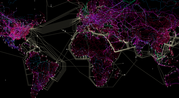
You begin your book by talking about your passion for cartography, and the books itself contains several beautiful maps. You also have an ongoing digital project called the Connectivity Atlas, which maps open-source infrastructure data around the world. Why was visualizing the ideas in this book so important to you?
We are a visual species. Maps are deeply instructive about our relationship with geography, and that’s one of [the] most visceral relationships we have as individuals. They’re politically significant because of their legal value and propaganda value.
I’m only the latest in the line of thousands of years of people who are producing maps to depict how reality is, and to cast a vision for how our future should be. What is special, I suppose, is that my maps are not about politicalgeography; my maps are about functional geography. These maps are very grounded, very physical, very empirical, very tangible, but also a futuristic and evolutionary view of what the world’s infrastructures are becoming.
The caliber that they were made at by the two best cartography labs in America—Harvard and Wisconsin—that is special. They’re the crown jewels.
Lastly, do you have any favorite maps from the book you’d like to highlight?
My favorite map would have to be [one showing] the global mega-cities and their economic value. This is simply the most accurate map ever made of where we are located as humanity, how we are densely populated into megacity archipelagos, and the economic importance of those clusters.
And then the Eurasia Silk Roads map. Most of the world’s population lives on this map. Eurasia is now being connected into a seamless megacontinent. This is literally the biggest story of the 21st century by far.